At the surface of the planet, sea ice across Arctic waters grows and shrinks seasonally, usually reaching its annual maximum in March. In 2026, this peak occurred on March 15, when the measurement reached 14.29 million square kilometers, which is the lowest level observed since satellite monitoring began in 1979. One of the important areas that contributed to the low number this year was the Barents Sea.
The Barents Sea borders the Arctic Ocean, bordered to the northwest by the Norwegian archipelago of Svalbard, and to the northeast and east by the Russian islands of Franz Josef Land and Novaya Zemlya respectively. It’s one of less than a dozen areas — including the Central Arctic Ocean and nearby oceans, bays and waterways — that scientists use to remotely detect ice from sea ice. This area is important for fishing, shipping lanes, and scientific research.
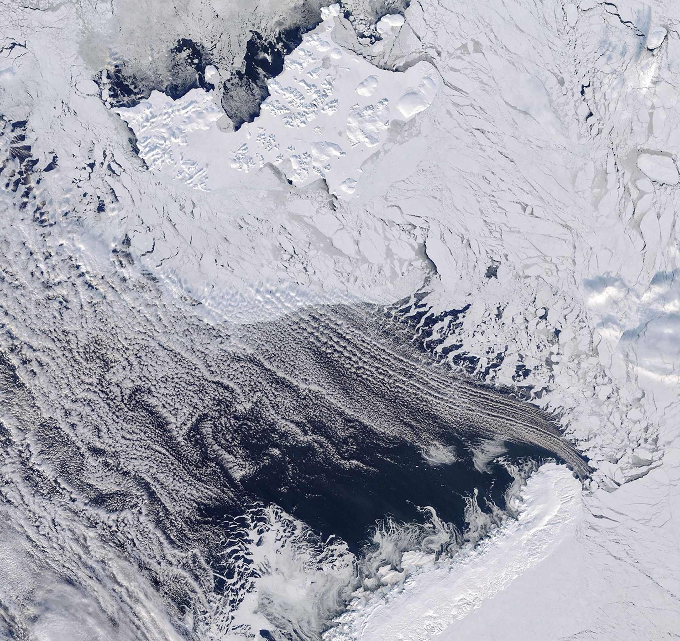
On March 17, 2026, the Terra satellite captured this image of the northern Barents Sea. Near Franz Josef Land, broken sea ice drifted along the open water near Novaya Zemlya. The area is usually cloudy, as it was that day, but most of the clouds were thin enough to reveal the ice and water below the sea.
In addition to the low level, data from NASA’s ICESat-2 satellite show that the Barents sea ice in mid-March 2026 was also very thin, according to Nathan Kurtz, head of the Cryospheric Sciences Laboratory at NASA’s Goddard Space Flight Center.
Previous years, such as 2021 and 2025, have also seen very thin ice during the peak. “What was interesting this year, however, was that the ice had also completely melted in the Barents Sea, in addition to the weak areas spreading to the north,” Kurtz said.
On the other side of the Arctic, the Sea of Okhotsk also contributed to the reduction of sea ice across the Arctic in March 2026. But the factors driving the loss are different between the two regions.
In the Barents, studies have shown that the main driver is a large atmospheric circulation, with winds that transport warm, moist air from the North Atlantic to the region, accelerating the melting. These winds can be influenced by tropical climates thousands of kilometers away. Disturbances in the Maritime Continent near Indonesia could “create waves in the atmosphere that reach the Arctic within a week to two,” Kurtz said.
On the other hand, the Sea of Okhotsk usually has thin seasonal ice that changes in thickness from year to year. Local winds play a major role, sometimes pushing the ice together to form thick, ridged areas, and sometimes spreading it, making it thinner. For this reason, ice loss there is mainly influenced by the climate of the area, unlike in the Barents Sea, where distant atmospheric forces have a greater influence.
NASA Earth Observatory image by Michala Garrison, using MODIS data from NASA EOSDIS WHEAT and GIBS/Worldview. Story by Kathryn Hansen.
- NASA (2026, March 26) Arctic Winter Sea Ice Ties Record Low, NASA, NSIDC Scientists Find. Accessed April 2, 2026.
- National Snow and Ice Data Center (2026) MASIE-NH Daily Image Viewer. Accessed April 2, 2026.
- National Snow and Ice Center (2026, March 25) Arctic sea ice reports record lows again. Accessed April 2, 2026.
- Nihashi, S. and al. (2018) Estimation of sea ice thickness and sea level in the Sea of Okhotsk based on ICESat data. Records of Glaciology59 (76pt2), 101-111
- NOAA (2025) Regional Sea Ice. Accessed April 2, 2026.
- Yu Feng Siew, P. and al. (2023) Physical Links from Atmospheric Circulation Patterns to Barents–Kara Sea Ice Variability from Synoptic to Seasonal Timescales in the Cold Season. Journal of Climate36, 8027–8040.
- Zheng, C. and al. (2022) Turbulent Heat Flux, Downward Longwave Radiation, and Large-Scale Atmospheric Circulation Associated with Wintertime Barents–Kara Sea Extreme Sea Loss Events. Journal of Climate, 35, 3747–3765.
#Barents #Sea #Bound #Arctic #Sea #Ice #NASA #Science